Technology for Nature
Data-driven insights for land, forests, and agriculture.
Data-driven insights for land, forests, and agriculture.
At Korotu, we build award-winning software to measure, monitor, and protect nature. Our services combine advanced remote sensing and AI technology with expert analysis, delivering the insights you need to effectively report on your critical environmental efforts, strengthen agroforestry systems, track forests, and more.
Now Available on the App Store
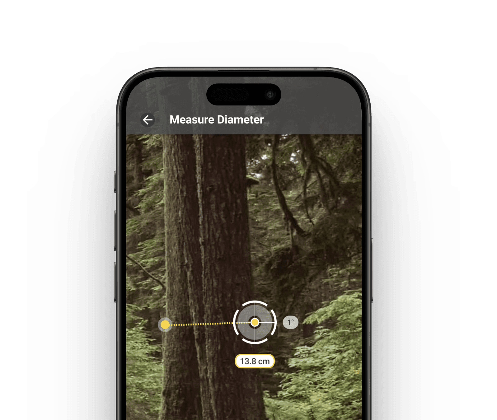
CarbonCruise
CarbonCruise
Now Available on the App Store
Our mobile app for collecting forest data has just officially launched on the App Store in Canada. Start measuring today!
Our mobile app for collecting forest data has just officially launched on the App Store in Canada. Start measuring today!
Now Available on the App Store
CarbonCruise
CHALLENGE
The Data Gap in
Environmental Stewardship
The Data Gap in
Environmental Stewardship
The Data Gap in
Environmental Stewardship

In the face of climate change and biodiversity loss, managing and protecting the earth’s natural assets is more critical than ever.
Reliable data is essential to measure and verify environmental impact, yet traditional monitoring methods are often slow, costly, and inaccessible. This creates a critical data gap, making it difficult to respond to threats, validate carbon stocks, or unlock funding for conservation.
We have less than 10 years to avert the most severe impacts of climate change.
Source: Global warming of 1.5℃, Intergovernmental Panel on Climate Change (IPCC), 2018
Nature can deliver over 30% of the climate solution through protecting and restoring ecosystems.
Source: Natural Climate Solutions, Bronson W. Griscom, 2017
Yet today, only 3% of global climate funding is directed toward natural climate solutions.
Source: Global Landscape of Climate Finance, Climate Policy Initiative, 2019
At Korotu, we are working to close this gap, driving better monitoring, verification, reporting and financing for natural solutions.
At Korotu, we are working to close this gap, driving better monitoring, verification, reporting and financing for natural solutions.
We have less than 10 years to avert the most severe impacts of climate change.
Source: Global warming of 1.5℃, Intergovernmental Panel on Climate Change (IPCC), 2018
Nature can deliver over 30% of the climate solution through protecting and restoring ecosystems.
Source: Natural Climate Solutions, Bronson W. Griscom, 2017
Yet today, only 3% of global climate funding is directed toward natural climate solutions.
Source: Global Landscape of Climate Finance, Climate Policy Initiative, 2019
At Korotu, we are working to close this gap, driving better monitoring, verification, reporting and financing for natural solutions.
OUR SERVICES
Expert support for your unique environmental challenges
Our team of remote sensing and GIS specialists offer tailored consulting services, from canopy cover assessments, carbon analysis, environmental monitoring, and more. We partner with you to transform complex data into actionable strategies for land stewardship, conservation and funding proposals.
Have a project in mind?
Get in touch
Get in touch

Custom Monitoring Solutions
Tailored insights for land, forests, and farms using satellite, drone, and field data.

Canopy Cover & Prioritization
Collect detailed canopy data to support environmental analysis, prioritization and reporting.

Agroforestry Planning & Implementation
Secure funding and support to implement agroforestry solutions that boost your farm's resilience.

Carbon Analysis & Verification
We measure, verify, and report carbon stocks, providing insights to support climate goals.

Proposal Development & Funding Strategy
We craft data-backed proposals and reports to secure environmental funding.

Environmental Data for Litigation
We deliver defensible environmental data for legal and regulatory use.
OUR SERVICES
Expert support for your unique environmental challenges
Our team of remote sensing and GIS specialists offer tailored consulting services, from canopy cover assessments, carbon analysis, environmental monitoring, and more. We partner with you to transform complex data into actionable strategies for land stewardship, conservation and funding proposals.
Have a project in mind?
Get in touch
Get in touch
Custom Monitoring Solutions
Tailored insights for land, forests, and farms using satellite, drone, and field data.
Canopy Cover & Prioritization
Collect detailed canopy data to support environmental analysis, prioritization and reporting.
Agroforestry Planning & Implementation
Secure funding and support to implement agroforestry solutions that boost your farm's resilience.
Carbon Analysis & Verification
We measure, verify, and report carbon stocks, providing insights to support climate goals.
Proposal Development & Funding Strategy
We craft data-backed proposals and reports to secure environmental funding.
Environmental Data for Litigation
We deliver defensible environmental data for legal and regulatory use.
OUR PRODUCTS
Aroa Platform
The Aroa Platform is our award-winning software for environmental measurement, reporting & verification (MRV). It processes and unifies satellite, drone, and field data into a single dashboard, providing clear, insights for forests, grasslands, wetlands, and croplands.


OUR PARTNERS
Who we serve
Who we serve
Who we serve
We partner with the people and organizations dedicated to protecting and managing our natural world.
We partner with the people and organizations dedicated to protecting and managing our natural world.
We partner with the people and organizations dedicated to protecting and managing our natural world.
Farmers and Farming Communities
We provide actionable data on your farm's natural assets, helping you access grant funding and improve farm resilience.
Sustainability-focused Forestry Companies
We provide precise tree inventory data to enhance sustainable management, increase operational efficiency, and validate environmental claims.
Indigenous Communities
We support Indigenous-led stewardship with tools to monitor and protect Indigenous lands. Our verifiable data provides critical evidence for land rights, resource management, and litigation.
Governments & Municipalities
We deliver data-driven insights that streamline large-scale environmental monitoring, compliance reporting, and climate adaptation planning.
Conservation Organizations
We provide the robust data you need to monitor project success, report to funders, and maximize your conservation impact.
Landowners & Private Estates
We provide a clear view of your natural assets to inform land stewardship, optimize ecological value, and identify revenue opportunities like carbon credits.
GET IN TOUCH
Contact us
Have a project in mind or want to learn more about how our technology can help? Please fill out the form below and we'll get back to you as soon as possible.


Let's build a more resilient
future together.
Let's build a
more resilient
future together.
Let's build a more resilient
future together.
Technology for Nature
Data-driven insights for land, forests, and agriculture.
At Korotu, we build award-winning software to measure, monitor, and protect nature. Our services combine advanced remote sensing and AI technology with expert analysis, delivering the insights you need to effectively report on your critical environmental efforts, strengthen agroforestry systems, track forests, and more.
